A semi-autonomous 100-miler through three Japanese mountain ranges to the shores of Lake Biwa
Other trail races within 165 miles
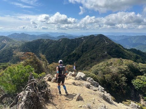
Lake Biwa 100 is a point-to-point 100-mile journey through Japan's Kansai region, tracing the flanks of Lake Biwa—Japan's largest lake—across three distinct mountain ranges. Starting from the hot spring resort of Yunoyama Onsen in Mie Prefecture, runners traverse the rugged Suzuka Mountains (including Mt. Gozaisho at 1,212m), cross through Shiga Prefecture along the Tokai Nature Trail, climb the steep peaks near the 100km mark, ascend the sacred Mt. Hiei with its famous Enryakuji Temple home to the Marathon Monks, and tackle the demanding Hira mountain range before a steep final descent to the shores of Lake Biwa. With minimal course marking and GPS navigation required throughout, this semi-autonomous race demands both athletic fitness and mountaineering judgment. Technical ridgelines require chain-assisted scrambles, narrow ridge traversals demand careful footwork, and sections through forests, rice paddies, residential neighborhoods, and ancient pilgrimage sites give the route a distinctly Japanese character. A Hardrock 100, Western States, and UTMB World Series qualifier. Many finishers dive into Lake Biwa to celebrate.
Experienced ultrarunners
Komono, Mie, JapanOctober 30, 2026

Must meet custom qualifier requirements within the qualification window
Must meet one of: (1) completed Lake Biwa 100 in 2022–2024; (2) completed a trail running race of 100 miles or more since 2022; (3) UTMB or ITRA performance index of 450 or higher in the 100M category as of time of entry. Must be 18 or older on race day. Elite invitation available for runners with UTMB Index above 840 (M) or 720 (F).
| Location | km | Elevation |
|---|---|---|
スタート 湯の山温泉希望荘 Start | 0.0 | 290 m |
W1 御在所山 Aid Station | 7.1 | 1,160 m |
A1 安楽峠 Aid Station | 27.2 | 495 m |
A2 鈴鹿峠 Aid Station | 33.3 | 376 m |
A3 余野公園 Aid Station | 46.2 | 259 m |
A4 黄瀬交流館さらら Aid Station | 74.8 | 265 m |
A5 田上枝公園 Aid Station | 97.0 | 100 m |
W2 長等公園 Aid Station | 113.9 | 164 m |
A6 北白川小学校 Aid Station | 125.8 | 83 m |
W3 伊香立 Aid Station | 144.1 | 551 m |
A7 還来神社 Aid Station | 149.6 | 226 m |
ゴール カーメルビーチクラブ前ビーチ Finish | 170.0 | 90 m |
Sign in to see cutoffs, crew access, drop bags, and services for every aid station.
Late October nights in mountain terrain can drop below 5°C above 800m. Mandatory warm layers, hat, and gloves required.
Autumn rain is common in the Japanese mountains. Wet rocky sections and chain-assisted scrambles become dangerously slippery. Waterproof jacket and trousers are mandatory.
Weather can change rapidly across three different mountain ranges over the 52-hour window. Prepare for a wide range of conditions.
No required gear specified
No recommended gear specified
No reviews for this event yet. Be the first to share your experience!


