A 124-mile BC wilderness epic through three provincial parks
Other trail races within 136 miles


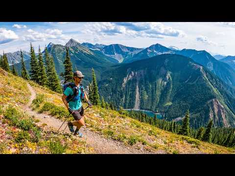
The Fat Dog 120 Mile is a grueling 124-mile point-to-point journey through three provincial parks in southwestern British Columbia, beginning at Cathedral Provincial Park's Lakeview Trailhead near Keremeos and finishing at Lightning Lake in E.C. Manning Provincial Park. The remote course features five major climbs, a ford of the Pasayten River, and nearly 26,000 feet of elevation gain across technical singletrack where cell service is nonexistent for long stretches. Runners travel from hot valley floors up into stunning sub-alpine terrain with panoramic ridgeline vistas — a race widely compared to Hardrock 100 in both difficulty and beauty.
Recommended for seasoned ultrarunners
Keremeos, BC, CanadaAugust 06, 2027
Fat Dog 120 Mile is a point-to-point trail race in Keremeos, BC, Canada, held on August 06, 2027. The course covers 199.6 km, climbs 7,998 m, and has a 48h cutoff.

Must complete a 100K race or longer within the qualification window
Minimum 100km experience within the past two years required (race or self-supported single effort). Completing a 100-mile race is highly recommended. Pacers are strongly encouraged for first-timers for at least the final stretch. Racers registering without a qualifying event will be moved to the next available distance with no refund until a qualifier is on file.
All racers must complete one of: 8 hours of trail work with Fat Dog or another sanctioned group, 8 hours of volunteering at another event (not crewing/pacing), or a $120 CAD donation to the trail fund via UltraSignup. Proof must be submitted by July 15.
| Location | km | Elevation | Cutoff | Crew | Pacers | Drop bags |
|---|---|---|---|---|---|---|
Start Line Start | 0.0 | 852 m | — | |||
Cathedral Aid Station Aid Station | 13.0 | 2,141 m | — | |||
Ashnola Aid Station Aid Station | 27.6 | 1,190 m | 7h5:00 PM | Crew | Drop Bags | |
Trapper Aid Station Aid Station | 34.7 | 1,810 m | — | |||
Calcite Aid Station Aid Station | 53.8 | 1,396 m | — | Drop Bags | ||
Pasayten River Checkpoint | 60.8 | 1,012 m | — | |||
Bonnevier Aid Station Aid Station | 63.7 | 1,021 m | 15h1:00 AM +1 | Crew | Pacers | Drop Bags |
Heather Aid Station Aid Station | 81.7 | 2,046 m | — | |||
Nicomen Lake Aid Station Aid Station | 97.1 | 1,791 m | — | |||
Grainger Creek Aid Station Aid Station | 107.0 | 953 m | — | |||
Hope Pass Aid Station Aid Station | 123.5 | 1,609 m | 30h4:00 PM +1 | Crew | Pacers | Drop Bags |
Nicomen Lake Aid Station (Return) Aid Station | 134.2 | 1,791 m | — | |||
Heather Aid Station (Return) Aid Station | 149.7 | 2,046 m | — | |||
Blackwall Peak Aid Station Aid Station | 162.8 | 1,796 m | — | Crew | Pacers | Drop Bags |
Windy Joe's Aid Station Aid Station | 173.5 | 1,192 m | 42h4:00 AM +2 | Crew | Pacers | |
Strawberry Flats Aid Station Aid Station | 181.4 | 1,370 m | 44h6:00 AM +2 | Crew | Pacers | Drop Bags |
Finish Line Finish | 199.0 | 1,244 m | 48h10:00 AM +2 | Crew | Drop Bags |
Aid station details for this race are still being filled in. Cutoffs and access rules come from the race’s own published information and can change — check the official race details before planning around them.
Sign in for race-day weather at every station, points of interest, segment-by-segment analysis, pacing, and to save this race to your calendar.
Camping available in Manning Provincial Park campgrounds and along Ashnola River Road near the 120M start. No overnight vehicle parking at aid stations or along roadways. Trail work days include first-come, first-served camping at Manning Park or along Ashnola River Road.
Afternoon thunderstorms are common over BC mountains in August; exposed sub-alpine ridgelines present significant lightning risk
Temperatures can swing from hot valley conditions (30°C+) to near-freezing on high passes; runners experience full seasonal extremes in one race
No required gear specified
No recommended gear specified
No reviews for this event yet. Be the first to share your experience!
