Trailrace logo
Find your race Find a Qualifier
Search Dashboard Saved Races Calendar
Trailrace logo

Helping the trail running community discover, plan for, and thrive at the world's best trail races.

Feedback

  • Send Feedback
  • Feature Requests
  • Report a Bug

Company

  • About
  • Roadmap

Legal

  • Terms of service
  • Privacy policy

© 2026 Trailrace.co. All rights reserved.

Built on bad decisions in Boulder, CO.

Les sentiers des Valdôtains

Basic Listing
  1. UTMB
  2. 2026 Edition
UTMB World Series

120km from the Matterhorn to Monte Rosa through the soul of the Italian Alps

Directions
Registration OpensSeptember 02, 2025
Register

Nearby races

Other trail races within 134 miles

Gran Trail Courmayeur GTC100

Gran Trail Courmayeur GTC100

100K
Courmayeur, AO, IT
Jul 10, 2026
62.14 miles
24,280 ft gain
Loop
Crew
Dropbags
18 mi away
Swiss Peaks Trail Legend

Swiss Peaks Trail Legend

250 Mile
Le Bouveret, VS, CH
Aug 30, 2026
246.68 miles
90,320 ft gain
Point to Point
Crew
50 mi away
L'Échappée Belle Intégrale

L'Échappée Belle Intégrale

100 Mile
Aiguebelle, Savoie, FR
Aug 21, 2026
94.45 miles
37,370 ft gain
Point to Point
Crew
Pacers
Dropbags
51 mi away
Swiss Alps 100 160KM

Swiss Alps 100 160KM

100 Mile
Fiesch, VS, CH
Aug 7, 2026
99.05 miles
33,300 ft gain
Loop
Crew
Pacers
Dropbags
60 mi away
Eiger Ultra Trail E250 UNESCO Trail
Qualifier Req

Eiger Ultra Trail E250 UNESCO Trail

200 Mile
Grindelwald, Bern, CH
Jul 15, 2026
158.04 miles
51,520 ft gain
Loop
Crew
Dropbags
71 mi away
Swiss Canyon Trail 51K

Swiss Canyon Trail 51K

50K
Couvet, NE, CH
May 30, 2026
32.75 miles
6,100 ft gain
Loop
Crew
88 mi away
Lake Züri 100

Lake Züri 100

100K
Zürich, ZH, CH
Mar 28, 2026
65.87 miles
10,950 ft gain
Loop
Crew
Pacers
Dropbags
126 mi away
Ultra-Trail des Coursières

Ultra-Trail des Coursières

100K
Saint-Martin-en-Haut, Rhône, FR
May 9, 2026
63.67 miles
14,000 ft gain
Loop
Pacers
Dropbags
134 mi away
All trail races in Valle d'Aosta→
July 17, 2026
Friday 6:30pm GMT+2 start
Aosta, Valle d'Aosta
Italy
120 km
Point to Point Course
7,908 m
Elevation Gain
Open Registration
No lottery
No Service Requirement
Does not require trail or volunteer work
No Qualifier
No qualifier race required
Very Challenging
Experienced ultrarunners
Fills Up Fast
High demand — register as soon as possible
Links
WebsiteInstagramFacebookYouTube
2025
Established
61%
Finish Rate
16:41 M / 18:02 W
Course Record

What Makes It Great

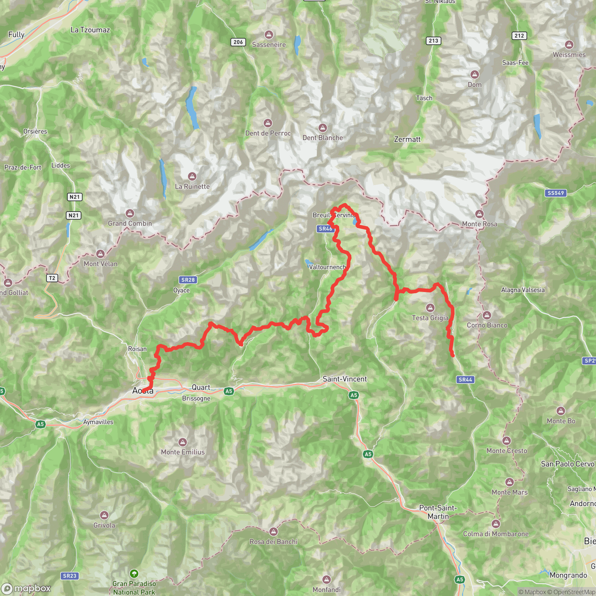
An extraordinary point-to-point journey through the heart of the Italian Alps, running 120km from Aosta's historic city center to the Walser village of Gressoney-Saint-Jean. The route traverses six valleys and passes beneath two of Europe's most iconic 4,000-meter peaks — the Matterhorn and Monte Rosa — climbing through ancient Walser communities, alpine meadows, and high mountain passes. The course includes a dramatic high-altitude crossing near Cime Bianche (~3,000m), before descending into the Monte Rosa massif for a finish in the storied Gressoney Valley.

Difficulty

Advanced
8/10

Experienced ultrarunners

Technical Terrain
Steep Climbing
High Altitude
Night Running
Variable Weather
Exposed Ridgeline

Race Highlights

Two 4,000m Alpine giants
The route passes beneath both the Matterhorn and Monte Rosa, the two most iconic peaks in the western Alps
120km point-to-point epic
Traverses six valleys from Aosta's city center to the Walser village of Gressoney-Saint-Jean
Cime Bianche high crossing
A dramatic ~3,000m alpine traverse above the Monte Rosa massif before the final descent
4 Running Stones + Finals access
One of the highest-value UTMB World Series events, awarding direct qualification to the UTMB Finals
Walser cultural immersion
Threads through ancient Walser villages, a Germanic community that has inhabited these Italian valleys since the 13th century

Les sentiers des Valdôtains

Aosta, Valle d'Aosta, ItalyJuly 17, 2026

July 17, 2026
Course map for Les sentiers des Valdôtains
DistDistance120 km
GainElevation Gain7,908 m
LimitCutoff36 h
Steep ClimbingHigh AltitudeNight RunningVariable WeatherExposed Ridgeline

Entry Timeline

Registration OpensSeptember 02, 2025
Race DayJuly 17, 2026

Lottery

This event uses open registration - no lottery entry required.

Qualifier

This event does not require a qualifier for entry.

Service Requirement

This race does not have a service requirement for entry.
120.0 km
Distance
Point to Point
Route
36h
Cutoff Time
1,924 m
Average Elevation
7,908 m
Total Ascent
7,212 m
Total Descent
2,988 m
High Point
685 m
Low Point
Course map
Launch Course Explorer

Aid Stations

LocationkmElevation
Aosta
Start
0.0580 m
Blavy
Aid Station
10.11,470 m
Valchourda
Aid Station
23.32,377 m
Saint-Barthelemy
Aid Station
34.91,888 m
Torgnon
Aid Station
40.51,859 m
Antey-Saint-André
Aid Station
47.21,029 m
La Magdeleine
Aid Station
52.61,627 m
Chamois
Landmark
58.91,823 m
Cheneil
Aid Station
63.02,101 m
Breuil Cervinia
Aid Station
76.52,008 m
Colle Cime Bianche
Aid Station
85.82,980 m
Champoluc
Aid Station
97.91,572 m
Sitten
Aid Station
107.02,291 m
Gressoney-La-Trinité
Aid Station
111.91,626 m
Rifugio Alpenzu
Aid Station
115.81,781 m
Gressoney-Saint-Jean
Finish
119.61,380 m

Sign in to see cutoffs, crew access, drop bags, and services for every aid station.

Crew Access Points

Pacer Rules

No Pacers Allowed

Crew Rules

  • One supporter per runner is permitted at designated aid stations. Checkpoints are marked as either 'assistance permitted' or 'no assistance permitted' on the race map and website. Supporters must not interfere with other runners.
Weather

July racing in the Aosta Valley brings highly variable conditions across the 120km course. Valley sections near Aosta can reach 30°C+ during the afternoon start. As the course climbs above 2,000m conditions shift dramatically, with temperatures potentially dropping to -10°C near the Cime Bianche crossing (~3,000m). Afternoon and evening thunderstorms are common in the Alps in July, with risk of rain, hail, or snow on the highest sections. Runners will experience at least one full night on course and should prepare for the full spectrum of alpine conditions.

Heat Training Recommended

Race starts at 18:30 in Aosta — valley temperatures can exceed 30°C in July

Cold/Hypothermia Risk

Above 2,000m temperatures can drop to -10°C; mandatory gear includes warm and waterproof layers

Lightning/Thunderstorm Risk

Afternoon and evening thunderstorms common in the Alps in July; exposed sections above 2,500m are particularly at risk

High Altitude

Course reaches ~3,000m at Cime Bianche; sustained time above 2,000m for most of the back half of the course

Gear Rules

Trekking poles allowed

Required Gear

No required gear specified

Recommended Gear

No recommended gear specified

Videos & Race Reports

No videos or race reports available for this event yet.

Reviews

to write a review.

No reviews for this event yet. Be the first to share your experience!

Register•July 17, 2026